Our first glimpse of the Azores - actually Peter's first glimpse, Lee and I were fast asleep - was of Flores. A sensational island of black volcanic treacherous cliffs, topped by a green patchwork of fields, topped by green clad ancient, conical volcanoes. Flores was wilder but still typical of the archipelago topography. They sprouted as mere dots in the North Atlantic as three tectonic plates - the Eurasian, the African plates and the North Atlantic ridge moved against each other. For millions of years, lava has seeped to the surface to form volcanoes while new rock along the ridge pushed older rock outward causing the Atlantic Ocean to widen by 0.5 cm a year, according to our guide. Peter and I cruised to seven of the nine Azore islands. Each one unique within a typical Azores template. All are low key touristy. All have fabulous and challenging hikes. Few have real beaches and those that do are small and black/grey. The tourist who will appreciate their visit likes land and water nature, hiking, cheese, wine, volatile history, proud and friendly people who are attached to their traditions and does not necessarily want to swim in the ocean because to our thin tropical, ex-hardy-Canadian blood, it's cold!. This post is an introduction to our introduction to each island from the sea
 |
| First sighting of Flores after 11 days at sea. A very welcome sight but not so welcoming. Dramatically beautiful, but fierce coastline. |
 |
| Small white houses with red roofs are on every island, few and far between especially on Flores where the population is shrinking so dramatically that it would be cheaper to move inhabitants to the mainland than to keep the infrastructure going, according to a hiking companion. |
 |
| For our ten days on Flores, there was usually low cloud. This is the second largest town, Lajes, where we anchored. Two supermarkets, one included appliances and hardware, two restaurants loosely speaking, a church and that's about it. But charming! |
 |
| Arrival! Lee and I sporting as many clothes as we could because it was cold! But, nonetheless, so happy to be anchored! |
 |
| Whaling was a source of wealth in the islands until not that long ago in 1987. There seems to be a whaling museum on every island, although Peter and I agreed without ever discussing it, not to attend as our interest in whales is different than an interest in whaling. The Azorean whalers were considered to be the best in the world. At each port, there is a ramp where the whales were hauled for slaughter and the cliffs overlooking the sea are dotted with whale watching points where those watching could signal whales whereabouts through flags and flares to the boats below. The islanders keep the tradition alive by taking great care of and racing these whaling skiffs. |
 |
| Huge sail on these narrow boats without keel - just macho ballast flung from side to side. We saw a couple capsize in the wild and woolly sea. |
 |
| Departing beautiful Flores for Faial. |
 |
| Tiny hamlets on Flores, perched on cliffs or nestled along a narrow shoreline, life is not easy here. The complete lack of the ability to consume anything but the very basic was startling - this is Europe, after all - but to our liking. What is there to do? Well, farming, hiking, socializing, surviving - and so the young are leaving. If you like the looks of it, go! They could use your tourist dollars along with the 200 or so other tourists who go. |
 |
| Lajes do Floress...we loved it. |
 |
| Flores and Corves are isolated to the east of the rest of the archipelago. After a night sail, we reached Faial, home of the famous - for sailors - Horta Marina. This view is of the northwest tip of the island where a volcano erupted in 1958. Completely desolate. The lighthouse, miraculously, survived. Horta, itself, was largely damaged in a 1998 earthquake. The earth is still rumbling here as we discovered when hiking. |
 |
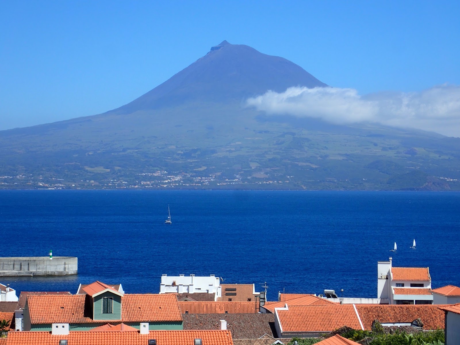
| First sighting of Pico, the highest peak in Portugal at 2,351m and just across a small strait from Horta where we docked. It is the only volcano on the islands that didn't implode to create a crater so it is still a perfect conceal peak. It was our backyard view. Not bad! |
 |
| Again, black cliffs, field quilt. |
 |
| Faial approach. |
 |
| We regret not climbing Pico. On the days we were able to go, the peak was covered in cloud. Friends of ours climbed it in the evening, saw the sunset, slept at the top (on the rock, not so nice) and woke to the sunrise. I guess we'll just have to return one day. |
 |
| This is Monte da Guia connected to Horta by a small isthmus. Caves looked intriguing as we sailed past. |
 |
| It's tough to edit. From the marina |
 |
| Even though full, the marina never turns boats away. Most have come across the sea from the west or the north to get there. Horta is known as the crossroads of the Atlantic. At peak season, which only lasts about six weeks, boats are rafted together sometimes four abeam. We happened to be assigned to raft to a boat whose crew we had briefly met in Bermuda while watching the tall ships. They were returning home to England after a three year cruise to Canada where their attempt at the northwest passage had been thwarted by a cold summer. Instead, they explored Greenland and Newfoundland for two seasons. Intrepid. |
 |
| I know, you've seen it. But those red roofs in the foreground are new. |
 |
| San Jorge, our third island, was lovely. Not quite as worldly, if I can use that word to describe Faial, but lively and enchanting. The port was still under construction as you can see by the crane but still with Pico in the distance. This was our bow view while at anchor. |
 |
| Our stern view was of this cliff which looks nondescript in the pic. It was exceedingly high and precipitous. At dusk it became a pickup bar for Cory Shearwaters, a large seabird that we often came across in enormous, floating flocks on the sea. Thousands, no exaggeration, came to roost/mate/chat each night for a few hours. Then they settled until dawn when they woke, chatted some more and took off for a day of fishing. As it was dark when they did whatever they did, we couldn't see them, but we sure could hear them. They chuckled, chatted, caroused - sounded like a huge party with one or two particular loudmouths above the general din. |
 |
| A stand up paddle board race... |
 |
| and a PWC race at our back door. We rooted for the paddlers. |
 |
| Some of those Cory Shearwaters sitting around. |
 |
| Had to take a picture of the local fisherman sporting a Canadian flag. Everyone has a relative who lives in Canada. This guy was in the marina in Terceira, the fifth island on our tour. Angra do Heroismo was declared a UNESCO world heritage city in 1983 while restoration after a 1980 earthquake was still underway. Azores chic and historical. Lovely. |
 |
| Skipping Sao Miguel which, being covered in cloud, we don't seem to have sea shots of, on to Santa Maria the seventh and, sadly, last island on our tour. Instead of volcanic, it is sedimentary rock. Still with cliffs and the only island with what we would call beaches. |
 |
| Largest and only town in Santa Maria was also the locale of the marina and the ferry dock and a nice restaurant/bar, the only things at the bottom of this very steep hill. Everything else was at the top. Needless to say, we frequented the only bar with the other cruisers. |
 |
| On our way to Portugal. Good-bye, Azores. So glad we met you. |
 |
| We hiked there... |
 |
and there.
|
Next up, "Hiking in the Azores" - there are too many beautiful pictures - "Flowers in the Azores" and "Bullfights in the Azores". We liked it there!


No comments:
Post a Comment